| SIZE: | 7,936 hectares |
|---|---|
| TARGET: | Precious metal (gold-silver) shear-hosted and dilational veins, intrusion related |
| INFRASTRUCTURE: | Proximity to Stewart and Tidewater |
- Located on Portland Canal tidewater, 18 km south of Stewart;
- Gold discovered in the valley as early as 1912;
- Gold mining in the1920s and 1930s produced roughly a kilogram of gold;
- Work from the 1970s to 2010 focused almost exclusively on the old gold mine;
- 2010 mapping showed the mine to be located in the periphery of an intensely deformed zone including sheared intrusions of the Early Jurassic Texas Creek Plutonic Suite which represents a large, gold bearing hydrothermal system;
- 2010 airborne survey delineated a 1 km² zone of an anomalous conductivity coincident with the mapped zone of intense defamation and probably caused by a blind, conductive target beneath the zone;
- A targeted synthetic aperture radar study (SAR) has identified 2 structural targets near the margins of a large intrusion of Texas Creek plutonic suite;
- The larger of the SAR targets is surrounded by small gold-bearing mineral occurrences worked in the 1920s and:
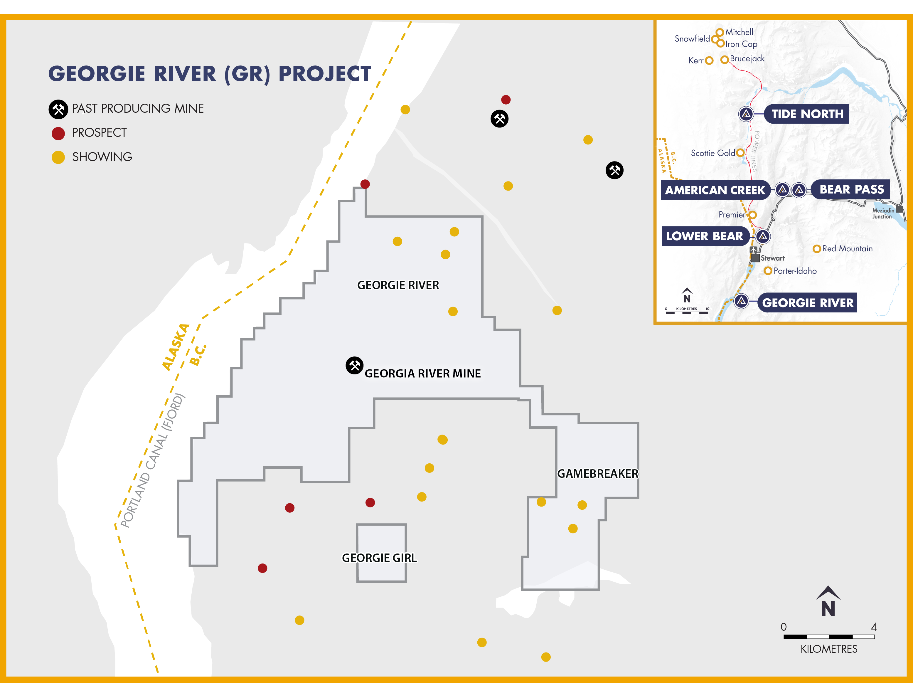
- These targets, lying outside the immediate mine area, have not been explored for more than 30 years; some have never been explored.The Georgie River Project (GR) is located at Portland Canal tidewater, in the watershed of the North Georgie and East Georgie Rivers, 18 km south of Stewart. It comprises 4 main areas: 1. The Georgie River area immediately east of the Canal including the newly acquired Exdale Property and the Hume Creek deformation zone; 2. The legacy Gamebreaker tenures to the southeast; 3. The Georgie Girl anomaly to the south and: 4. The area of the old mine workings, 75% optioned to Decade Resources Ltd.
All three areas in the GR Project are intimately associated with intrusions of the metallogenic, gold bearing Texas Creek plutonic suite. On the northeast edge of the main Georgie River area is a 7 km contact with the early Jurassic (Texas Creek) Bulldog Creek Pluton. On Colling Ridge are numerous exposures of Colling Ridge porphyry, equivalent in age to the Bulldog Creek Pluton. Lastly, the Outram Lake porphyry and the Gamebreaker area are equivalent in Early Jurassic age to the Bulldog Creek and Colling Ridge intrusions.
The remaining component required for an economic gold deposit is rock disrupted by folding, shearing, volcanic or hydrothermal brecciation. An abundance of such disruption occurs in each area within the GR Project, in part determined by old-fashioned geological mapping, in part determined by cutting edge analysis of synthetic aperture radar data. This area is therefore highly prospective for intrusion related gold deposits related to the Texas Creek Plutonic Suite (TCPS), analogous to other large deposits in the Golden Triangle.